
Showing posts with label amerika. Show all posts
Showing posts with label amerika. Show all posts
Sunday, July 31, 2011
Friday, July 29, 2011
Tuesday, July 26, 2011
Easter Island in Chile

Easter Island is an island belonging to Chile is located in the southern Pacific Ocean. Although the distance is 3515 km west of mainland Chile.
Easter Island is shaped like a triangle. Nearest land is uninhabited Pitcairn Island is a distance of 2075 km west. Easter Island wide by 163.6 km ². According to the 2002 census, the population numbered 3791 souls majority settled in the capital of Hanga Roa. The island is famous for its many statues (moai), 400-year-old statue carved from stone which now lies along the coastline.
Expert navigation Dutchman Jakob Roggeveen discovered Easter Island on Easter Sunday in 1722. Please note that the name "Rapa Nui" Easter Island is not the original name given by the tribe Rapanui. The name was coined by labor immigrants from Rapa in the original tribal Bass Islands, who equate it with his hometown. Rapanui tribal name given to this island is Te Pito o te henua ("Puser World") because of remoteness, but the address is also taken from another location, possibly from a building in the Marquesas
.


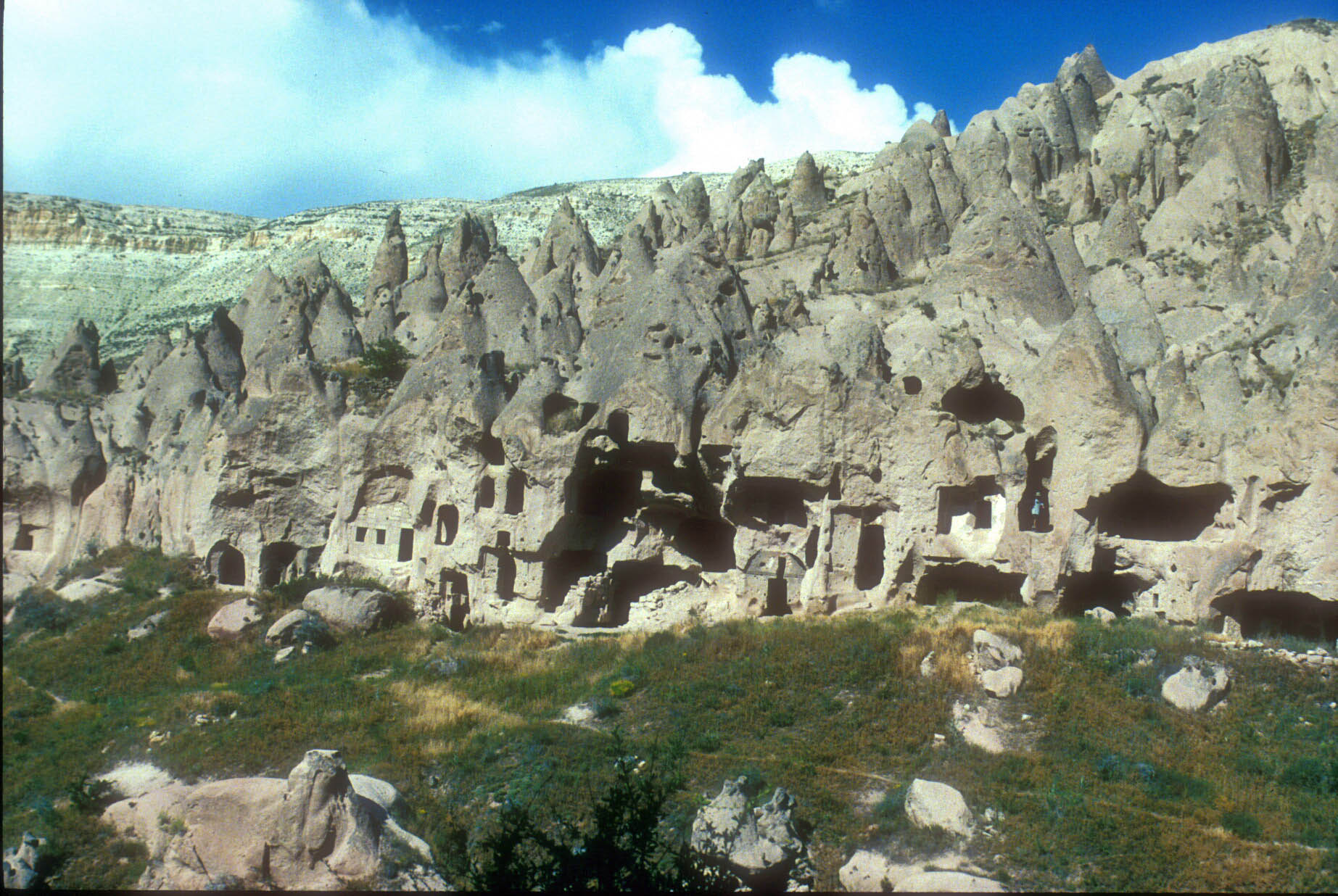
animals that live in the bermuda triangle

Sargasso Sea is one of the sea with a lot of mountains and there are many steep canyon with an area of approximately 1.5 million square miles. Any ships or planes that cross this region typically have damage to the compass so that the compass continues to spin and can not tell a clear direction. This occurs due to strong magnetic fields that exist in the Sargasso Sea. Currents in the ocean is so strong that it is able to form a kind of vortex of water that flows clockwise.
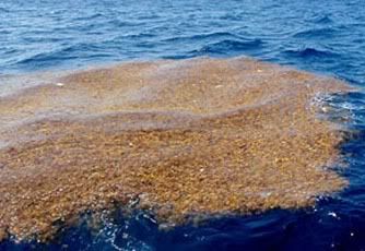
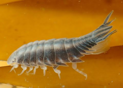
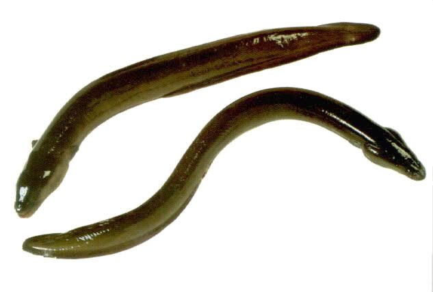
This animal lives in the Sargasso Sea which is also called the bermuda triangle sea.
1. algae Sargasso
2. parasitic isopods
3. eel
4. Sargasso Sea Horse

Monday, July 25, 2011
history of colorado river in amerika

Colorado River is one of the oldest and most beautiful rivers in the United States.Rivers that disgorge from Rokky Mountains, the water flows toward the southwest as far as 2,300 kilometers across the Mojave and Sonoran Deserts, until then reached Mexico .
Over millions of years supposedly the story, the flow of the Colorado River formed the Grand-Canyon, a magnificent gorge as a gift of God the Creator to the human race on American soil. However during the last 100 years, the Colorado River became the source of most water dredged in the face of the earth. For example, the six dams that collect water from this river, including Glen Canyon and Hoover Dam, take advantage of this river for the benefit arigasi and also supplies electricity to the metropolis like Los Angeles and Phoenix.
Now the Colorado River no longer flows into the Sea Cartez. Most of the water flowing in the south of Imperial Dam is diverted into the Salton Sea. Estuary is now barren and flat look. How was the Colorado River has special memories of the beauty of its natural for people who've seen it. The flow of the river forming the magnificent canyon of the Grand Canyon of Colorado.
Wonders of the Colorado River is the Grand Canyon, a cliff-steep ravine, carved by the Colorado River, in northern Arizona. This gap is one of the Seven Wonders of the World and mostly located in the Grand Canyon National Park, one of the first national parks in the United States. President Theodore Roosevelt is one of the main supporters of the Grand Canyon area, visiting on numerous occasions to hunt mountain lion and enjoy the incredible natural scenery.


hotel card from the unique American
The building is constructed of 200 000 the card keys. Each room and every wall, even the toilets are made of card keys. The hotel is built by Bryan Berg, who has a world record in building a house of cards.


Saturday, July 23, 2011

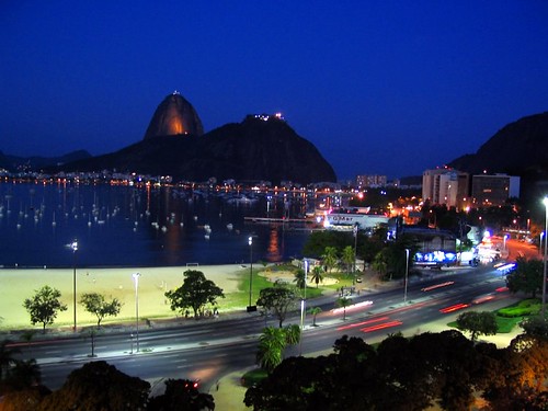


Sugar Loaf Mountain - Brasil

A mere 600 million years ago mother nature's geologic hand formed a princely natural wonder, Pao de Acucar or Sugar Loaf. Original inhabitants deemed it Pau-nh-Acqua, later to be changed by the invading French who dubbed it “Pot de Beurre”. Portuguese colonists renamed it “Pao de Assucar” or Bread of Sugar only to be re-invaded by the French who assigned it “Pot de Sucre”. By the Seventeenth century the Portuguese had regained their dominance and Pao de Acucar was reborn to permanency. During this time sugar cane was the primary export and upon completion of the processing the finished product was packed into bread like loaves for shipment. Hence the name Sugar Loaf.
Today Sugar Loaf is the most commonly recognized and sought after tourist attraction in Rio. But it has served its past inhabitants equally well. Navigators for years would spot the imposing figure as the entrance to Guanabara Bay. The first Portuguese arrivers chose the landmark as a settling location for the magnitude of visibility afforded towards the sea and mountains assuring their continued protection.
Today’s tourists enjoy the ease and comfort of a cable car ride to the top of Sugar Loaf which was first installed in 1912, blossoming the tourists industry to Rio.
Reaching the top of Sugar Loaf is actually done in two stages. The first car ascends over 700 feet up Urca Hill affording marvelous views of Corcovado Mountain, the Niteroi Bridge and Guanabara Bay. Transferring to a second car then elevates you an additional 1300 feet to the top where spectacular views of Copacabana and other beaches can be admired. Plan on about four hours round trip.
As with Corcovado, climbing the back side of Sugar Loaf is possible for the daring soldier. It’s not very well known because the hiking trail paths near where you catch the cable cars are blocked by a pillar to discourage the curious hiker. Walk around them and you’re on your way. Be advised. This is a very rugged climb and not for the uninformed, and once you reach the top you won’t want to climb down and you can’t buy a ticket at the top. Buy your one-way ticket first and take it with you.
Riding or walking, Sugar Loaf Mountain is a timeless attraction which should be taken advantage of by all who visit Rio. The views are gorgeous, the photo ops endless, and most of all the experience…..priceless!
Salt Cathedral, Zipaquirá - Colombia

The Zipaquirá Salt Cathedral is located not far from Bogotá and 180 meters underground. The site was used for salt exploitation since the times of the Spanish Conquest. At present, the former mines are a beautiful cathedral that became one of the most famous and visited religious destinations in Colombia. It is also considered one of the country’s most famous archaeological constructions.


